county/comté/grafschaft
一廊桥
14 covered bridges/ponts couverts/bedeckte holzbrücken
45-13 WINDHAM

Brattleboro
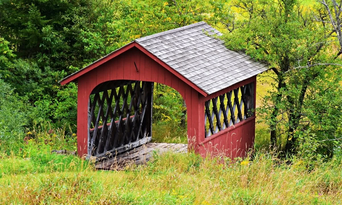
The Creamery Bridge
45-13-01
At the western edge of Brattleboro off VT 9.
Over Whetstone Brook.
The Creamery Bridge.
0.4 mile west of jct I-91 at exit 2 on VT 9
then just left at Guilford Street to the bridge.
1 span 84' or 25.6m
Built in 1879, sidewalk added in 1917.
Town lattice.
Photo by Alan B. Hartmann.

Dummerston
The West-Dummerston Bridge
45-13-02
North of West Dummerston off VT30
Over the West River.
The West-Dummerston Bridge, the longest covered bridge in Vermont!
7 miles NW of jct US 5 north of Brattleboro on VT 30 just past West-Dummerston then just right at the bridge.
2 spans 280' or 85.3m
Built in 1872 by Caleb B. Lamson, completely restored in 1998.
Town lattice.
Photos by Scott Wagner & Dave MacKenzie of VirtualVermont.

Grafton
The Kidder Bridge
45-13-03
South edge of Grafton on Bear Hill Road.
Over the South Branch of the Saxton River.
The Kidder Bridge.
0.1 mile east of the village of Grafton on VT 121 then right on Bear Hill Road 0.2 mile to the bridge.
1 span 70' or 21.3m
Built in 1870.
King Post truss.
Photo by Galen Frysinger.
Green-River
The Green River Bridge

45-13-04
At the village of Green River on Jacksonville Stage Road.
Over the Green River.
The Green River Bridge.
1.4 miles south of jct I-91 at exit 1 on US 5 to Guilford then right 4.1 miles to Guilford-Center and 0.6 mile ahead, then right 2.4 miles on Stage Road and left 0.1 mile to the bridge.
1 span 104' or 31.6m
Built in 1873 by Marcus Worden, restored in 2016.
Town lattice.
Photo by Jared Benedict on WIKIPEDIA.
Williamsville
The Williamsville Bridge

45-13-05
West of Williamsville on Dover Road.
Over the Rock River.
The Williamsville Bridge.
2.7 miles west of VT 30 at Dummerston/Newfane townline on the road to South-Newfane.
1 span 120' or 36.5m
Built in 1870 by Eugene P. Wheeler, replaced by a new bridge in 2010 by Alpine Construction of Schylerville, NY.
Town lattice.
Phots by Galen Frysinger.
Dummerston
The West-Dummerston Bridge

45-13-07 #2
East of Saxtons River on Paradise Hill Road.
Over the Saxtons River.
The Hall, Barber Park or Osgoode Bridge.
3.2 miles WNW of jct US 5 at Bellows Falls on VT 121 then just right.
1 span 120' or 36.5m
Built around 1870, rebuilt in 1982 by Milton S. Gratton.
Town lattice.
Photos by Galen Frysinger.

Bartonsville
The Worrall Bridge
45-13-10
South of Bartonsville off VT 103.
Over Williams River.
The Worrall Covered Bridge.
4.5 miles SE of jct of VT 11 at Chester on VT 103 then right 0.2 mile on Lower Bartonsville Road to the bridge.
1 span 86' or 26.2m
Built in 1868 by Sanford Granger, restored in 2010.
Town lattice.
Photos by Ray Hitchcock.
The Bartonsville Bridge

45-13-11
At the south edge of Bartonsville off VT103
Over Williams River.
The Bartonsville Bridge.
4 miles SE of jct VT 11 at Chester on VT103 then left 0.2 mile on Pleasant Valley Road to the bridge.
1 span 158' or 48.1m
Built in 1871 by Sanford Granger, destroyed by Hurrican Irene's flood waters August 28, 2011, rebuilt in 2012.
Town lattice.
All 3 pictures left from Galen Frysinger...
Below left, after the disaster, foto Will Truax.
The new bridge was opened on January 26, 2013.
Townshend
The Scott Bridge

45-13-13
West of Townshend off VT 30.
Over the West River.
The Scott Bridge, closed to motor traffic.
4.5 miles SE of jct VT 100 at East-Jamaica on VT 30 then just right.
3 spans 290' or 88.3m
Built in 1870 by Harrison Chamberlin.
Town & King truss.
Photos from former tc2u web page.
Rockingham
The Victorian Village Bridge

45-13-23
North-west edge of Rockingham off VT 103
Over Rock Brook.
The Victorian Village Bridge, private.
2.2 miles NW jct I-91 at exit 6 on VT 103 then just left at Vermont Country Store.
1 span 46' or 14m
Built in 1967 with timber from 45-13-12.
King post truss.
Photos by Robert W. Folk.
East-Wilmington
The High-Mowing or Twin Silos Bridge
45-13-A
North East of Wilmington.
Over Stowe Brook.
The High-Mowing or Twin Silos covered bridge.
1.5 miles north east of VT9 off VT100 and then right onto Stowe Hill Road.
1 span 22' or 6.7m
Built in 1949 by the Haynes Brothers.
Town lattice.
Photo James Jimbo.

Grafton
The Grafton Cheese Factory Covered Bridge
45-13-E
South west of Grafton off Townshend Road.
Over the South Branch of the Saxton River.
The Grafton Cheese Factory Covered Bridge.
0.5 mile south west VT121 Main Street in Grafton on the east side of Townshend road.
1 span 62' or 18.8m
Built in 1967 by the Windham Foundation.
Stringer.
Photo by Galen Frysinger.
Bondville
The Snow Covered Bridge

45-13-P
In the town of Bondville.
Over a ski trail or gully (summer time).
The Snow Covered bridge.
On access road to townhouses at Stratton Mountain Ski Area. The bridge is in Stratton, in the town of Bondville.
1 span 50' or 15.2m
No building date given.
Steel Stringer.
Photo from MAPIO.
West-Dover
The Hermitage Road Covered Bridge

45-13-S
At 25 Handle Road in West Dover.
Over Cold Brook.
The Hermitage Road covered bridge, private, Hermitage Inn owned by Donna and Jim Barnes.
About 8.5 miles north of VT9 on VT100 and then left onto Tannery Road and left again on Handle Road to the Heritage Inn at no. 25 on the right side of the road.
1 span 60' or 18.2m
Built in 2009, designed by John Guminak of Dover Vt.
Town lattice.